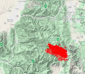
 A new fire start has been identified on the Camino Real Ranger District on the Carson National Forest. The fire, which has been named the Luna Fire, is currently burning at 11,000 elevation to 9,000 elevation. The fuel source is high elevation mixed Spruce down to Ponderosa Pine.
Fire personnel are currently en route to the fire, which is burning two miles north and northeast of Chacon, New Mexico. Smoke (and the smell of fire) may be visible in the surrounding communities of Angel Fire, Black Lake, Guadalupita, Mora and Taos.
More information will be released as it becomes available. There is no direct threat to these communities at this time. The cause of the fire is currently under investigation. Please avoid Forest Road 76.
Please visit the New Mexico Department of Health’s smoke page for information on protecting your health during fires and on smoky days: https://nmtracking.org/fire.
Location: Carson National Forest, Camino Real Ranger District
Size: 1,000+ acres
Cause: Unknown (under investigation)
Date Detected: Oct. 17, 2020
Evacuations: None
Fuel Type: High Elevation Mixed Spruce down to Ponderosa Pine
Values at Risk: Values at risk currently being assessed
Resources: Currently en route Avoid: Forest Road 76
MaryAnna Clemons
Public Affairs Officer
Forest Service
Carson National Forest
c: 575-999-5548
Monday to Friday from 7:30 am to 4:00 pm
maryanna.clemons@usda.gov
208 Cruz Alta Road
Taos, NM 87571
www.fs.fed.us
From the Angel Fire Fire Department
The Luna Fire is still being assessed and firefighting resources are responding. The initial size-up was 500 acres and growing due to the wind and currently estimated at 1000 acres. Eagle Nest Lake is closed to boating as of 0930 and may be used as a water resource (dip site for helicopters). There is no current threat to Angel Fire, but we are monitoring the situation closely. We may be impacted by smoke throughout the morning, and there is a potential the fire behavior could increase this afternoon if the wind shifts East/Northeast. Please avoid forest road 76. Trigger points have been established for evacuations in several communities in Mora County and we will assist as needed, but no resources have been requested from Angel Fire.
Please understand that the map below is satellite imagery that detects heat signatures. Due to strong winds last night, heat and smoke were carried quite far and this image may not be an actual representation of the fire.
Thank you,
Chief John Murtagh
Angel Fire Fire Department
Leave a Reply